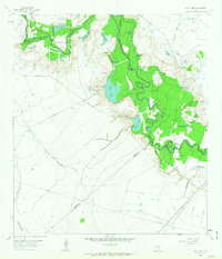
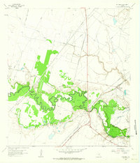
1978 Map of Vidaurri
USGS Topo · Published 1979About this map
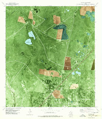
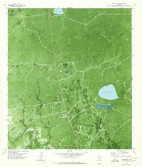
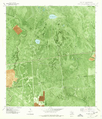
The Tom O'Connor Oil Field dominates the southern landscape of this coastal Texas region, where the energy industry integrates with long-standing ranching operations. Significant industrial infrastructure, including a Gas Plant, Pumping Sta, and a network of Pipelines, is clearly visible alongside cattle-country landmarks like the Welder Ranch. The terrain is defined by a series of shallow basins and waterways, most notably Sharps Lake, North St Nicholas Lake, and the meandering Melo Creek. The small settlement of Vidaurri and the community of Greta serve as focal points along the Missouri Pacific railroad line, which cuts diagonally across the plain. This orthophoto map provides a unique visual record of the 1970s landscape, showing the precise clearing patterns of oil pads and access roads within the brushy terrain.
Find a feature on this map
22 named features on this map. Tap any name to fly to it.
Don’t see what you’re looking for? This feature index may not catch every label — zoom into the map to look around manually.
Map Details
Editions of this 1978 Vidaurri Map
This is the sole edition of this map. No revisions or reprints were ever made.
Other maps of this area

1953 · Beeville
USGS Topo · 1:250,000
1954 · Vidaurri
USGS Topo · 1:62,500
1954 · Refugio
USGS Topo · 1:62,500

1956 · Beeville
USGS Topo · 1:250,000

1960 · Beeville
USGS Topo · 1:250,000
1962 · Live Oak Lake
USGS Topo · 1:24,000
1962 · Lott Lake
USGS Topo · 1:24,000
1962 · McFaddin
USGS Topo · 1:24,000
1978 · Ryanville
USGS Topo · 1:24,000
1978 · Twin Mott Lake
USGS Topo · 1:24,000