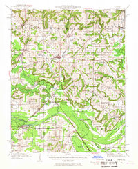
1942 Map of Vienna
USGS Topo · Published 1967About this map
The Cache River and its intricate drainage network define this Southern Illinois landscape, where the Post Creek Cutoff and various ditches like Clifty Creek Ditch illustrate early 20th-century water management. Centered on the town of Vienna, the area shows a dense distribution of rural institutions, including the Ridenhower School, Oak Grove School, and Mt Olive Church.
Find a feature on this map
96 named features on this map. Tap any name to fly to it.
Don’t see what you’re looking for? This feature index may not catch every label — zoom into the map to look around manually.
Map Details
Editions of this 1942 Vienna Map
2 editions found

Other maps of this area

1917 · Brownfield
USGS Topo · 1:62,500

1918 · Vienna
USGS Topo · 1:62,500

1919 · Vienna
USGS Topo · 1:62,500

1920 · Dongola
USGS Topo · 1:62,500

1922 · Carbondale
USGS Topo · 1:62,500

1923 · Dongola
USGS Topo · 1:62,500

1925 · Marion
USGS Topo · 1:62,500

1925 · Harrisburg
USGS Topo · 1:62,500

1926 · Paducah
USGS Topo · 1:62,500

1928 · La Center
USGS Topo · 1:62,500