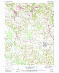
1966 Map of Vienna
USGS Topo · Published 1990About this map
Vienna serves as the focal point of this Southern Illinois survey, situated at the junction of the Burlington Northern railroad and several regional highways. The landscape is defined by the winding course of the Cache River and Little Cache Creek, with significant acreage protected within the Shawnee National Forest. Notable for its high density of family cemeteries and rural parishes, the map documents sites like Sutliff Cem, Rose Hill Cem, and Mt Zion Ch, which anchor the surrounding communities of Buncombe and Bloomfield. The map includes important water management and industrial features, such as the Dutchman Lake reservoir, the Sewage Disposal Pond serving the city, and several Quarries and a Gravel Pit that point to the local extraction economy during the mid-to-late twentieth century.
Find a feature on this map
43 named features on this map. Tap any name to fly to it.
Don’t see what you’re looking for? This feature index may not catch every label — zoom into the map to look around manually.
Map Details
Editions of this 1966 Vienna Map
3 editions found
Other maps of this area

1918 · Vienna
USGS Topo · 1:62,500

1919 · Vienna
USGS Topo · 1:62,500

1920 · Dongola
USGS Topo · 1:62,500

1922 · Carbondale
USGS Topo · 1:62,500

1923 · Dongola
USGS Topo · 1:62,500

1925 · Marion
USGS Topo · 1:62,500

1940 · Marion
USGS Topo · 1:62,500

1941 · Carbondale
USGS Topo · 1:62,500

1942 · Vienna
USGS Topo · 1:62,500

1949 · Paducah
USGS Topo · 1:250,000