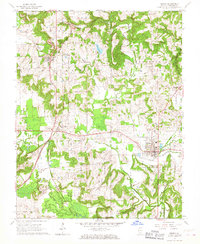
1966 Map of Vienna
USGS Topo · Published 1967About this map
The county seat of Vienna serves as the focal point of this mid-1960s survey, where the convergence of the Chicago and Eastern Illinois and Burlington and Quincy railroads once drove the local economy. The landscape is deeply carved by the Cache River and its tributaries, including Little Cache Creek and Dutchman Creek, which wind through the township boundaries of Elvira, Bloomfield, and Vienna. Genealogists will find a dense concentration of family and community burial sites, from the large Vienna Cemetery to smaller locations like Peterson Cem, Simpson Cem, and Huey Cem. Beyond the main town, smaller settlements like West Vienna and Buncombe are documented alongside landmarks such as the Fairground and Oak Grove Sch, providing a detailed view of Johnson County life before later highway developments altered the rural character.
Find a feature on this map
42 named features on this map. Tap any name to fly to it.
Don’t see what you’re looking for? This feature index may not catch every label — zoom into the map to look around manually.
Map Details
Editions of this 1966 Vienna Map
3 editions found
Other maps of this area

1918 · Vienna
USGS Topo · 1:62,500

1919 · Vienna
USGS Topo · 1:62,500

1920 · Dongola
USGS Topo · 1:62,500

1922 · Carbondale
USGS Topo · 1:62,500

1923 · Dongola
USGS Topo · 1:62,500

1925 · Marion
USGS Topo · 1:62,500

1940 · Marion
USGS Topo · 1:62,500

1941 · Carbondale
USGS Topo · 1:62,500

1942 · Vienna
USGS Topo · 1:62,500

1949 · Paducah
USGS Topo · 1:250,000