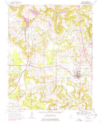
1966 Map of Vienna
USGS Topo · Published 1978About this map
Vienna serves as a focal point in this southern Illinois survey, situated at a junction where the Burlington Northern, Missouri Pacific, and Conrail rail lines once converged. The landscape is defined by the winding course of the Little Cache River and its many tributaries, including Dutchman Creek and McCorkle Creek. In the township of Elvira, the settlement of Buncombe sits near several small family burial grounds such as Jenkins Cem and Peterson Cem, reflecting the deep-rooted local genealogy of the area. Significant topographical features like Wildcat Bluff contrast with industrial sites like the local Quarries and Gravel Pit. The map captures a period of transition, showing the newly constructed Interstate 57 cutting through the western portion of the quadrangle near West Vienna, forever altering the traditional overland routes through Bloomfield and Cache townships.
Find a feature on this map
43 named features on this map. Tap any name to fly to it.
Don’t see what you’re looking for? This feature index may not catch every label — zoom into the map to look around manually.
Map Details
Editions of this 1966 Vienna Map
3 editions found
Other maps of this area

1918 · Vienna
USGS Topo · 1:62,500

1919 · Vienna
USGS Topo · 1:62,500

1920 · Dongola
USGS Topo · 1:62,500

1922 · Carbondale
USGS Topo · 1:62,500

1923 · Dongola
USGS Topo · 1:62,500

1925 · Marion
USGS Topo · 1:62,500

1940 · Marion
USGS Topo · 1:62,500

1941 · Carbondale
USGS Topo · 1:62,500

1942 · Vienna
USGS Topo · 1:62,500

1949 · Paducah
USGS Topo · 1:250,000