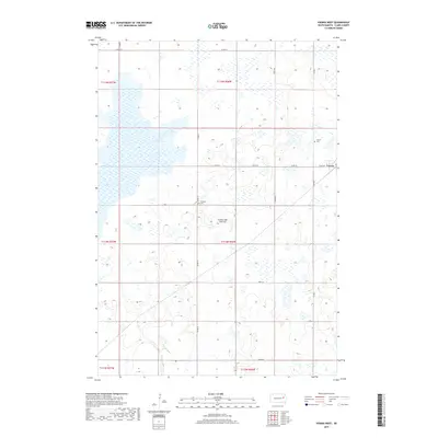
2017 Map of Vienna West
USGS Topo · Published 2017About this map
Coteau des Prairies, a vast highland plateau, shapes the undulating geography of this Clark County region. The western edge of the town of Vienna is situated on the eastern boundary of the map, served by a network of rural routes including Clark Ave and Co Rd 9. The landscape is defined by its glacial heritage, most notably seen in Dry Lake Number Two, a significant water body that dominates the northwestern quadrant. Local history and genealogy are anchored by two prominent sites: Vienna Cem at the town’s edge and Pleasant Cem further west along Co Rd 12. This 2017 survey reflects the enduring agricultural and prairie character of the South Dakota plains, where section lines and county roads provide the primary structure for movement across the wetland-dotted terrain.
Find a feature on this map
22 named features on this map. Tap any name to fly to it.
Don’t see what you’re looking for? This feature index may not catch every label — zoom into the map to look around manually.
Map Details
Editions of this 2017 Vienna West Map
This is the sole edition of this map. No revisions or reprints were ever made.
Other maps of this area

1953 · Watertown
USGS Topo · 1:250,000

1958 · Watertown
USGS Topo · 1:250,000

1973 · Willow Lake
USGS Topo · 1:24,000

1973 · Clark South
USGS Topo · 1:24,000

1973 · Bryant
USGS Topo · 1:24,000

1973 · Vienna West
USGS Topo · 1:24,000
1973 · Cherry Lake
USGS Topo · 1:24,000

1973 · Naples
USGS Topo · 1:24,000
1973 · Willow Lake SW
USGS Topo · 1:24,000

1973 · Vienna East
USGS Topo · 1:24,000