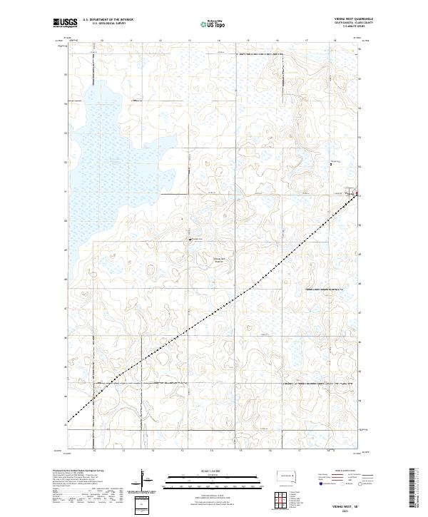
2021 Map of Vienna West
USGS Topo · Published 2021About this map
Coteau des Prairies defines the rolling, pothole-dotted landscape of this South Dakota quadrangle, where glacial topography has created a complex network of wetlands and seasonal basins. The most prominent water feature is Dry Lake Number Two, a large, shallow depression in the northwestern corner that typifies the region's interior drainage. The town of Vienna sits at the eastern edge of the sheet, serving as the primary hub for the surrounding agricultural community. For family historians, the map identifies local burial grounds including Vienna Cem and Pleasant Cem, while a systematic grid of county roads like Co RD 12 and 185th ST provides access across the townships. This layout illustrates a persistent pattern of land use where section lines dictate the movement of people and commerce through the prairie.
Find a feature on this map
22 named features on this map. Tap any name to fly to it.
Don’t see what you’re looking for? This feature index may not catch every label — zoom into the map to look around manually.
Map Details
Editions of this 2021 Vienna West Map
This is the sole edition of this map. No revisions or reprints were ever made.
Other maps of this area

1953 · Watertown
USGS Topo · 1:250,000

1958 · Watertown
USGS Topo · 1:250,000

1973 · Willow Lake
USGS Topo · 1:24,000

1973 · Clark South
USGS Topo · 1:24,000

1973 · Bryant
USGS Topo · 1:24,000

1973 · Vienna West
USGS Topo · 1:24,000
1973 · Cherry Lake
USGS Topo · 1:24,000

1973 · Naples
USGS Topo · 1:24,000
1973 · Willow Lake SW
USGS Topo · 1:24,000

1973 · Vienna East
USGS Topo · 1:24,000