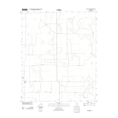
2012 Map of Vigo Park
USGS Topo · Published 2012About this map
Vigo Park serves as the primary community anchor in this High Plains landscape, situated at the junction of Co Rd 29 and Ranch Road 146. The area is characterized by large agricultural and ranching operations, reflecting the legacy of Texas panhandle land use. Numerous family-named holdings like Hall Ranch, Hulsey Ranch, and the McMurtry Farm are dispersed across the quadrangle, connected by a structured grid of rural roads including Co Road HHH and Zulu Rd. The topography is relatively flat, punctuated by seasonal depressions and the drainage of Deer Cr near Hulsey Springs. The Vigo Park Airport provides a specialized transport link for this agricultural hub, while more remote holdings such as Cobb Ranch and Tule Ranch mark the boundaries of the local ranching network.
Find a feature on this map
22 named features on this map. Tap any name to fly to it.
Don’t see what you’re looking for? This feature index may not catch every label — zoom into the map to look around manually.
Map Details
Editions of this 2012 Vigo Park Map
This is the sole edition of this map. No revisions or reprints were ever made.
Other maps of this area

1954 · Plainview
USGS Topo · 1:250,000

1958 · Plainview
USGS Topo · 1:250,000

1960 · Wayside
USGS Topo · 1:62,500

1963 · Pleasant Creek
USGS Topo · 1:24,000
1963 · Gip Creek
USGS Topo · 1:24,000

1965 · Ross Canyon
USGS Topo · 1:24,000

1965 · Big Betty Reservoir
USGS Topo · 1:24,000

1965 · Vigo Park
USGS Topo · 1:24,000

1965 · Cope Creek
USGS Topo · 1:24,000

1969 · Love
USGS Topo · 1:24,000