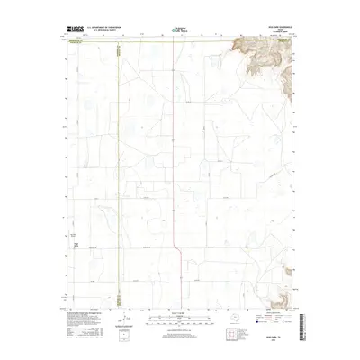
2016 Map of Vigo Park
USGS Topo · Published 2016About this map
The small community of Vigo Park serves as the primary landmark in this section of the Texas Panhandle, situated near the intersection of the Swisher, Armstrong, and Briscoe county lines. The landscape is defined by the expansive high plains, punctuated by the localized drainage of Hulsey Springs in the northeast. The rural infrastructure of the mid-2010s is clearly delineated, featuring a grid of agricultural routes such as Zulu Rd and Ranch Rd 146. Aviation history in the area is represented by the Vigo Park Airport, while the larger ranching heritage of the region is reflected in the presence of Tule Ranch Rd. This survey illustrates the persistent agricultural and ranching character of the Llano Estacado, where human settlement is concentrated around established crossroads and vital water sources.
Find a feature on this map
20 named features on this map. Tap any name to fly to it.
Don’t see what you’re looking for? This feature index may not catch every label — zoom into the map to look around manually.
Map Details
Editions of this 2016 Vigo Park Map
This is the sole edition of this map. No revisions or reprints were ever made.
Other maps of this area

1954 · Plainview
USGS Topo · 1:250,000

1958 · Plainview
USGS Topo · 1:250,000

1960 · Wayside
USGS Topo · 1:62,500

1963 · Pleasant Creek
USGS Topo · 1:24,000
1963 · Gip Creek
USGS Topo · 1:24,000

1965 · Ross Canyon
USGS Topo · 1:24,000

1965 · Big Betty Reservoir
USGS Topo · 1:24,000

1965 · Vigo Park
USGS Topo · 1:24,000

1965 · Cope Creek
USGS Topo · 1:24,000

1969 · Love
USGS Topo · 1:24,000