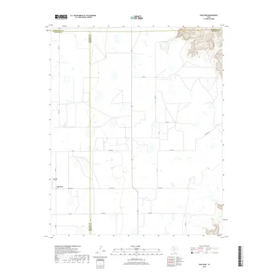
2019 Map of Vigo Park
USGS Topo · Published 2019About this map
Vigo Park stands at the heart of this High Plains landscape, situated near the intersection of Swisher and Armstrong counties. The area is defined by a systematic grid of section roads, including Zulu Rd and Ranch Rd 146, which facilitate the region's agricultural and ranching operations. To the northeast, the terrain breaks away from the flat caprock into the broken canyonlands near Hulsey Springs, where the elevation drops sharply towards the Briscoe County line.
Find a feature on this map
19 named features on this map. Tap any name to fly to it.
Don’t see what you’re looking for? This feature index may not catch every label — zoom into the map to look around manually.
Map Details
Editions of this 2019 Vigo Park Map
This is the sole edition of this map. No revisions or reprints were ever made.
Other maps of this area

1954 · Plainview
USGS Topo · 1:250,000

1958 · Plainview
USGS Topo · 1:250,000

1960 · Wayside
USGS Topo · 1:62,500

1963 · Pleasant Creek
USGS Topo · 1:24,000
1963 · Gip Creek
USGS Topo · 1:24,000

1965 · Ross Canyon
USGS Topo · 1:24,000

1965 · Big Betty Reservoir
USGS Topo · 1:24,000

1965 · Vigo Park
USGS Topo · 1:24,000

1965 · Cope Creek
USGS Topo · 1:24,000

1969 · Love
USGS Topo · 1:24,000