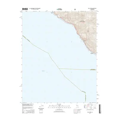
2015 Map of Villa Creek
USGS Topo · Published 2015About this map
The Santa Lucia Range rises sharply from the Central Coast in this 2015 survey, where the terrestrial landscape of Los Padres National Forest meets the vast expanse of the Pacific Ocean. This coastal boundary marks the transition between Monterey County and San Luis Obispo County, a rugged interface defined by steep drainages like Redwood Gulch and Villa Cr. The maritime environment is punctuated by offshore hazards and landmarks, most notably Whaleboat Rock to the north and White Rock Number Two further down the coast. The mapping of Spruce Cr and Alder Cr illustrates the drainage patterns typical of this mountainous shoreline, where short, steep watercourses carve through the Santa Lucia Range to reach the sea. This record preserves the precise location of these canyons and coastal features in the early 21st century.
Find a feature on this map
13 named features on this map. Tap any name to fly to it.
Don’t see what you’re looking for? This feature index may not catch every label — zoom into the map to look around manually.
Map Details
Editions of this 2015 Villa Creek Map
This is the sole edition of this map. No revisions or reprints were ever made.
Other maps of this area

1919 · Piedras Blancas
USGS Topo · 1:62,500

1921 · Cape San Martin
USGS Topo · 1:62,500

1927 · Piedras Blancas
USGS Topo · 1:62,500

1941 · Cape San Martin
USGS Topo · 1:62,500

1942 · Cape San Martin
USGS Topo · 1:62,500

1947 · San Luis Obispo
USGS Topo · 1:250,000

1948 · San Luis Obispo
USGS Topo · 1:250,000
1948 · Cape San Martin
USGS Topo · 1:62,500
1949 · Villa Creek
USGS Topo · 1:24,000
1949 · Burro Mountain
USGS Topo · 1:24,000