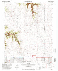
1996 Map of Villegreen
USGS Topo · Published 2000About this map
Villegreen stands as the primary namesake settlement in this high-plains landscape of Las Animas County, where the topography is defined by the sharp descent into Plum Creek Canyon. The map reveals a transition from the plateau-like surfaces of Dalerose Mesa and the drainage of Plum Creek to the protected expanse of the Comanche National Grassland in the southern portion. The presence of several Springs and a isolated Spring tucked within the canyon walls suggests the critical importance of water sources in this semi-arid environment. Infrastructure is sparse, characterized primarily by Villegreen Road and a solitary Communication Tower, illustrating the rural, open character of southeastern Colorado during the late twentieth century.
Find a feature on this map
10 named features on this map. Tap any name to fly to it.
Don’t see what you’re looking for? This feature index may not catch every label — zoom into the map to look around manually.
Map Details
Editions of this 1996 Villegreen Map
This is the sole edition of this map. No revisions or reprints were ever made.
Other maps of this area

1891 · Mesa De Maya
USGS Topo · 1:125,000

1892 · Mt Carrizo
USGS Topo · 1:125,000

1893 · Mesa de Maya
USGS Topo · 1:125,000

1955 · La Junta
USGS Topo · 1:250,000

1958 · La Junta
USGS Topo · 1:250,000

1968 · La Junta
USGS Topo · 1:250,000

1972 · Johnson Canyon
USGS Topo · 1:24,000

1972 · Miners Peak
USGS Topo · 1:24,000

1972 · Plum Canyon
USGS Topo · 1:24,000

1972 · Tobe
USGS Topo · 1:24,000