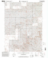
1997 Map of Vim School
USGS Topo · Published 2000About this map
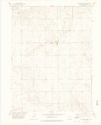
Pawnee National Grassland dominates this high plains landscape in Weld County, revealing a specialized ranching and energy-extraction economy during the late 1990s. The map illustrates the sparse but critical infrastructure of the region, where family-named landmarks like Bourlier Windmill, Kindvall Windmill, and Youngland Windmill mark essential water sources across the arid terrain. Educational history is anchored by the namesake Vim School and the Rockaway School, reflecting the distribution of rural community centers in an area defined by wide-open spaces and the seasonal flow of Twomile Creek.
Find a feature on this map
32 named features on this map. Tap any name to fly to it.
Don’t see what you’re looking for? This feature index may not catch every label — zoom into the map to look around manually.
Map Details
Editions of this 1997 Vim School Map
This is the sole edition of this map. No revisions or reprints were ever made.
Other maps of this area

1954 · Sterling
USGS Topo · 1:250,000

1954 · Scottsbluff
USGS Topo · 1:250,000

1958 · Scottsbluff
USGS Topo · 1:250,000

1958 · Sterling
USGS Topo · 1:250,000
1972 · Bushnell SW
USGS Topo · 1:24,000

1972 · Kimball SW
USGS Topo · 1:24,000

1972 · Bushnell SE
USGS Topo · 1:24,000
1977 · Pawnee Buttes
USGS Topo · 1:24,000
1977 · Vim School
USGS Topo · 1:24,000
1977 · Gatehook Spring
USGS Topo · 1:24,000