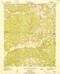
1951 Map of Vina
USGS Topo · Published 1951About this map
Vina serves as the primary hub along the Illinois Central railroad line in this mid-century survey of the northwest Alabama hill country. The landscape is defined by the Tennessee Divide, where water systems like Hurricane Creek and Bull Mountain Creek drain away from the prominent ridgelines. Local life is documented through a dense network of country schools and churches, including Good Spring Church and the Hurricane Sch, which anchored these rural communities before modern consolidation. A fascinating remnant of earlier transit, the Old Cotton Road winds through the northern hills, hinting at the historical agricultural routes that preceded the railway. Family history is preserved in small, scattered plots such as Brazel Cem and Jones Cem, located near the crossroads that once defined this portion of Franklin and Marion counties.
Find a feature on this map
54 named features on this map. Tap any name to fly to it.
Don’t see what you’re looking for? This feature index may not catch every label — zoom into the map to look around manually.
Map Details
Editions of this 1951 Vina Map
2 editions found

Other maps of this area

1936 · Hodges
USGS Topo · 1:24,000

1936 · Red Bay
USGS Topo · 1:24,000

1936 · Vina
USGS Topo · 1:24,000

1936 · Halltown
USGS Topo · 1:24,000

1936 · Guinn Cross Roads
USGS Topo · 1:24,000
1946 · Guinn Cross Roads
USGS Topo · 1:24,000
1947 · Guinn Cross Roads
USGS Topo · 1:24,000

1949 · Hodges
USGS Topo · 1:24,000

1950 · Vina
USGS Topo · 1:24,000
1950 · Halltown
USGS Topo · 1:24,000