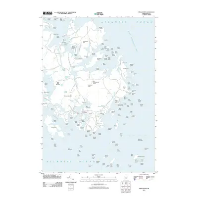
2011 Map of Vinalhaven
USGS Topo · Published 2011About this map
The town of Vinalhaven serves as the hub of this island landscape, where the coastline is deeply indented by coves and tidal passages like the Fox Islands Thorofare. The topography is marked by a history of resource extraction, evidenced by Lawson Quarry Pond and Booth Quarry Pond, which now punctuate the interior. For genealogists, the map is particularly rich, locating several ancestral burial grounds including the Lane Family Cemetery, John Carver Cemetery, and Roberts Cemetery. Access across the island's interior is defined by a network of winding roads like Calderwood Neck Rd and Ocean View Rd, while the Mary Talbot Memorial Airfield provides a modern connection to the mainland. The surrounding waters of East Penobscot Bay and Isle Au Haut Bay are filled with numerous named islands and ledges, such as Mount Ephraim Island and Starboard Rock.
Find a feature on this map
178 named features on this map. Tap any name to fly to it.
Don’t see what you’re looking for? This feature index may not catch every label — zoom into the map to look around manually.
Map Details
Editions of this 2011 Vinalhaven Map
This is the sole edition of this map. No revisions or reprints were ever made.
Other maps of this area

1904 · Deer Isle
USGS Topo · 1:62,500

1904 · Vinalhaven
USGS Topo · 1:62,500

1905 · Penobscot Bay
USGS Topo · 1:125,000

1906 · Matinicus
USGS Topo · 1:62,500

1941 · Vinalhaven
USGS Topo · 1:62,500

1942 · Deer Isle
USGS Topo · 1:62,500

1944 · Vinalhaven
USGS Topo · 1:62,500

1944 · Deer Isle
USGS Topo · 1:62,500

1948 · Bangor
USGS Topo · 1:250,000

1948 · Bath
USGS Topo · 1:250,000