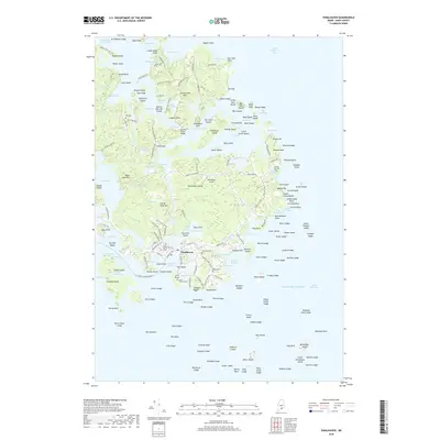
2018 Map of Vinalhaven
USGS Topo · Published 2018About this map
Vinalhaven serves as the central hub of this island landscape, where a complex network of coastal roads like Roberts Cemetery Rd and Cranberry Shore Rd connect scattered homesteads and local landmarks. The island's geography is defined by its deep maritime indentations, such as Winter Harbor and Carver Cove, alongside numerous inland water bodies including Long Pond and Lawson Quarry Pond. Genealogists will find significant value in the distribution of family and community burial sites, including the Carver Cem, Cummins Cem, and the Lane Family Cem. The northern edge of the island is bounded by the Fox Islands Thorofare, a vital passage separating the land from nearby points like Grindstone Ledge. Notable coastal features such as The Swimming Pool and Mill Priviledge suggest a long history of utilizing the tidal waters and natural inlets for both recreation and industry.
Find a feature on this map
204 named features on this map. Tap any name to fly to it.
Don’t see what you’re looking for? This feature index may not catch every label — zoom into the map to look around manually.
Map Details
Editions of this 2018 Vinalhaven Map
This is the sole edition of this map. No revisions or reprints were ever made.
Other maps of this area

1904 · Deer Isle
USGS Topo · 1:62,500

1904 · Vinalhaven
USGS Topo · 1:62,500

1905 · Penobscot Bay
USGS Topo · 1:125,000

1906 · Matinicus
USGS Topo · 1:62,500

1941 · Vinalhaven
USGS Topo · 1:62,500

1942 · Deer Isle
USGS Topo · 1:62,500

1944 · Vinalhaven
USGS Topo · 1:62,500

1944 · Deer Isle
USGS Topo · 1:62,500

1948 · Bangor
USGS Topo · 1:250,000

1948 · Bath
USGS Topo · 1:250,000