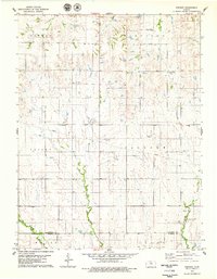
1978 Map of Vincent
USGS Topo · Published 1979About this map
Vincent and Cheyenne anchor this rural landscape along the southern border of Osborne County and Russell County during the late 1970s. The terrain is defined by a network of drainage systems including Coon Creek and Fourmile Creek, which carve through the townships of Covert, Winfield, and Valley. A notable geological landmark, Cheyenne Gap, provides a natural corridor in the north-central region, while the presence of a Quarry in the south suggests the local extraction of limestone or other minerals common to the Kansas plains.
Find a feature on this map
18 named features on this map. Tap any name to fly to it.
Don’t see what you’re looking for? This feature index may not catch every label — zoom into the map to look around manually.
Map Details
Editions of this 1978 Vincent Map
This is the sole edition of this map. No revisions or reprints were ever made.
Other maps of this area

1896 · Osborne
USGS Topo · 1:125,000

1955 · Beloit
USGS Topo · 1:250,000

1959 · Beloit
USGS Topo · 1:250,000

1978 · Osborne SW
USGS Topo · 1:24,000
1978 · Lucas
USGS Topo · 1:24,000
1978 · Luray
USGS Topo · 1:24,000
1978 · Osborne SE
USGS Topo · 1:24,000
1978 · Meades Ranch
USGS Topo · 1:24,000
1978 · Waldo
USGS Topo · 1:24,000
1978 · Covert
USGS Topo · 1:24,000