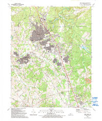
1991 Map of Vine Grove
USGS Topo · Published 1992About this map
The sprawling eastern landscape of the Fort Knox Military Reservation defines much of this Hardin County survey, showing the interface between federal land and the growing communities of Radcliff and Vine Grove. The residential expansion of the early 1990s is evident in developments like Dietz Acres and the concentrated streets of Rogersville. Running through the heart of the region, the Illinois Central Gulf railroad serves as a primary industrial spine, passing through Vine Grove Junction and near the North Hardin Tower.
Find a feature on this map
60 named features on this map. Tap any name to fly to it.
Don’t see what you’re looking for? This feature index may not catch every label — zoom into the map to look around manually.
Map Details
Editions of this 1991 Vine Grove Map
This is the sole edition of this map. No revisions or reprints were ever made.
Other maps of this area

1932 · Big Clifty
USGS Topo · 1:62,500

1935 · Elizabethtown
USGS Topo · 1:48,000

1936 · Vine Grove
USGS Topo · 1:62,500

1938 · Elizabethtown
USGS Topo · 1:62,500

1941 · Ekron
USGS Topo · 1:62,500

1943 · Vine Grove
USGS Topo · 1:62,500

1946 · Rock Haven
USGS Topo · 1:24,000

1946 · Pitts Point
USGS Topo · 1:24,000

1946 · Fort Knox
USGS Topo · 1:24,000

1946 · Colesburg
USGS Topo · 1:24,000