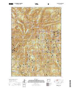
2020 Map of Vinegar Hill
USGS Topo · Published 2020About this map
The Greenhorn Mountains define this high-elevation corner of Northeast Oregon, where the boundaries of the Umatilla National Forest, Whitman National Forest, and Malheur National Forest converge. This 2020 survey documents a complex system of drainages including W Fork Granite Boulder Cr and Vinegar Cr, which descend from prominent peaks like Vinegar Hill and Ben Harrison Peak.
Find a feature on this map
58 named features on this map. Tap any name to fly to it.
Don’t see what you’re looking for? This feature index may not catch every label — zoom into the map to look around manually.
Map Details
Editions of this 2020 Vinegar Hill Map
This is the sole edition of this map. No revisions or reprints were ever made.
Other maps of this area

1901 · Sumpter
USGS Topo · 1:125,000

1951 · Bates
USGS Topo · 1:62,500

1951 · Desolation Butte
USGS Topo · 1:62,500

1955 · Canyon City
USGS Topo · 1:250,000

1959 · Canyon City
USGS Topo · 1:250,000

1972 · Austin
USGS Topo · 1:24,000
1972 · Granite
USGS Topo · 1:24,000

1972 · Greenhorn
USGS Topo · 1:24,000
1987 · Bates
USGS Topo · 1:100,000
1988 · Vinegar Hill
USGS Topo · 1:24,000