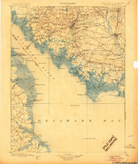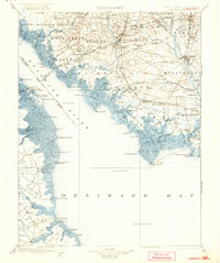
1899 Map of Vineland
USGS Topo · Published 1921About this map
The oyster industry and maritime trade of the Delaware Bay dominate this late 19th-century landscape, centered on the bustling rail termini of Bivalve and Port Norris. Surveyed between 1886 and 1896, the map reveals a complex network of coastal infrastructure, from the Cohansey Light and Ship John Light guiding vessels through the Delaware River to the numerous landings like Newport Ldg. and Canings Wharf. Inland, the planned community of Vineland and the industrial centers of Bridgeton and Millville show the region's transition from agricultural roots to a manufacturing economy served by the Central R. R. of New Jersey and the West Jersey and Seashore R. R. The southern reaches of Cumberland Co. are defined by intricate tidal marshes such as The Glades and Buckshutem Swamp, emphasizing the deep connection between the mainland settlements and the shifting shoreline of Maurice River Cove.
Find a feature on this map
157 named features on this map. Tap any name to fly to it.
Don’t see what you’re looking for? This feature index may not catch every label — zoom into the map to look around manually.
Map Details
Editions of this 1899 Vineland Map
3 editions found