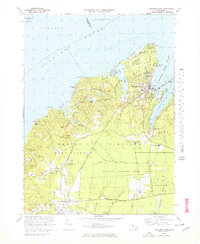
1972 Map of Vineyard Haven
USGS Topo · Published 1978About this map
Vineyard Haven serves as the focal point for this survey of the northern portion of the island, where the busy Vineyard Haven Harbor meets the open Vineyard Sound. This map documents a landscape defined by its coastal geography and early agricultural heritage, showing numerous Cranberry Bogs and the extensive Martha's Vineyard State Forest. To the south and west, the character shifts toward the rural villages of North Tisbury and West Tisbury, which are connected by historic routes like Lamberts Cove Road and State Road.
Find a feature on this map
86 named features on this map. Tap any name to fly to it.
Don’t see what you’re looking for? This feature index may not catch every label — zoom into the map to look around manually.
Map Details
Editions of this 1972 Vineyard Haven Map
3 editions found
Other maps of this area

1886 · Falmouth
USGS Topo · 1:62,500

1887 · Gay Head
USGS Topo · 1:62,500

1887 · Marthas Vineyard
USGS Topo · 1:62,500

1888 · Falmouth
USGS Topo · 1:62,500

1889 · Gay Head
USGS Topo · 1:62,500

1889 · Marthas Vineyard
USGS Topo · 1:62,500

1893 · Gay Head
USGS Topo · 1:62,500

1893 · Falmouth
USGS Topo · 1:62,500

1894 · Marthas Vineyard
USGS Topo · 1:62,500

1915 · Falmouth
USGS Topo · 1:62,500