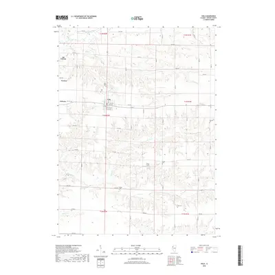
2018 Map of Viola
USGS Topo · Published 2018About this map
Viola serves as the central hub for this portion of Mercer County, where a grid of rural routes including 95th Ave and 17th St connects several smaller residential clusters. The landscape is defined by the winding drainages of the Edwards River to the north and the complex branching of Pope Creek and North Pope Creek to the south. Several historical burial grounds, such as Saint John's Cemetery and Bridger Cemetery, are situated near old settlement sites like Wanlock and Gilchrist. The northern edge of the map identifies Old Gilchrist, suggesting a shift in the local center of gravity over time. This survey captures a mix of agricultural tradition and modern infrastructure, evidenced by the presence of Young Airport amidst the rolling creek valleys and established township boundaries.
Find a feature on this map
42 named features on this map. Tap any name to fly to it.
Don’t see what you’re looking for? This feature index may not catch every label — zoom into the map to look around manually.
Map Details
Editions of this 2018 Viola Map
This is the sole edition of this map. No revisions or reprints were ever made.
Other maps of this area

1912 · Milan
USGS Topo · 1:62,500

1923 · Alexis
USGS Topo · 1:62,500

1925 · Alexis
USGS Topo · 1:62,500

1937 · Orion
USGS Topo · 1:62,500

1944 · Milan
USGS Topo · 1:62,500

1947 · Woodhull
USGS Topo · 1:62,500

1953 · Viola
USGS Topo · 1:24,000
1953 · Matherville
USGS Topo · 1:24,000
1953 · New Windsor
USGS Topo · 1:24,000
1953 · Orion
USGS Topo · 1:24,000