
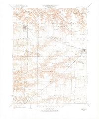
1932 Map of Virginia
USGS Topo · Published 1965About this map
The Sangamon Valley lowlands and dissected uplands of Cass and Morgan Counties are meticulously documented in this early twentieth-century survey. The landscape is defined by a dense network of one-room schoolhouses and rural churches that served the agricultural community, including Science Hill Sch, Brush College Sch, and Olive Branch Ch. The Baltimore and Ohio railroad corridor provides the primary industrial axis, connecting the larger settlements of Virginia, Philadelphia, and Ashland.
Find a feature on this map
75 named features on this map. Tap any name to fly to it.
Don’t see what you’re looking for? This feature index may not catch every label — zoom into the map to look around manually.
Map Details
Editions of this 1932 Virginia Map
2 editions found
Other maps of this area

1909 · Tallula
USGS Topo · 1:62,500

1924 · Winchester
USGS Topo · 1:48,000

1924 · Waverly
USGS Topo · 1:62,500

1926 · Beardstown
USGS Topo · 1:62,500

1926 · Winchester
USGS Topo · 1:62,500

1926 · Waverly
USGS Topo · 1:62,500

1929 · Arenzville
USGS Topo · 1:62,500

1930 · Chandlerville
USGS Topo · 1:62,500

1932 · Arenzville
USGS Topo · 1:62,500

1932 · Chandlerville
USGS Topo · 1:62,500