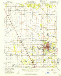
1949 Map of Visalia
USGS Topo · Published 1954About this map
Visalia serves as the bustling hub of this Central Valley landscape, its urban grid clearly defined against an intricate network of irrigation ditches and canals that fuel the region's agricultural economy. The map reveals a highly organized land-use pattern, where dozens of water features like Traver Canal, Modoc Ditch, and Tulare Irrigation Canal branch out to support a system of camps and ranches. Most notable is the cluster of worker camps associated with the Camp Tagus Ranch, including numbered sites from Camp One to Camp Ten, and its dedicated Camp Tagus Ranch School. Educational and social infrastructure is well-represented by the College of the Sequoias, Mooneys Grove Park, and the Sequoia Home (County). Transport and communication centers, including the Visalia Municipal Airport and the Southern Pacific rail lines, emphasize the city's role as a vital junction between the smaller outlying settlements of Goshen, Traver, and Yettem.
Find a feature on this map
106 named features on this map. Tap any name to fly to it.
Don’t see what you’re looking for? This feature index may not catch every label — zoom into the map to look around manually.
Map Details
Editions of this 1949 Visalia Map
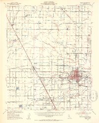
2 editions found
Other maps of this area

1921 · Stokes Mountain
USGS Topo · 1:24,000

1922 · Trimmer
USGS Topo · 1:96,000

1923 · Sultana
USGS Topo · 1:31,680

1924 · Reedley
USGS Topo · 1:31,680

1924 · Selma
USGS Topo · 1:31,680

1924 · Dinuba
USGS Topo · 1:125,000

1924 · Stokes Mountain
USGS Topo · 1:31,680

1925 · Tulare
USGS Topo · 1:31,680

1926 · Goshen
USGS Topo · 1:31,680

1926 · Burris Park
USGS Topo · 1:31,680