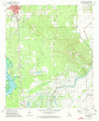
1971 Map of Vivian South
USGS Topo · Published 1973About this map
Oil and gas fields dominate the Caddo Parish landscape in the early 1970s, where extraction infrastructure intertwines with rural community life. The Kansas City Southern railroad serves as the primary spine of the region, connecting the larger settlement of Vivian to smaller points like Superior, Shoreline, and Oil City. The density of fossil fuel activity is juxtaposed against a surprisingly robust network of religious and educational institutions, including North Caddo High Sch and numerous country churches such as Mt Gilead Ch and Union Chapel. To the south and west, the map transitions into the complex wetlands of the Caddo-Pine Island region. Here, the waters of Caddo Lake and James Bayou define the terrain, while the Old Channel Black Bayou reflects the shifting hydrology of the area, creating a landscape where industry, swamp, and small-town residency coexist.
Find a feature on this map
51 named features on this map. Tap any name to fly to it.
Don’t see what you’re looking for? This feature index may not catch every label — zoom into the map to look around manually.
Map Details
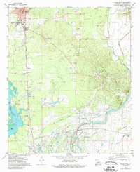
Editions of this 1971 Vivian South Map
2 editions found
Other maps of this area

1932 · Hosston NW
USGS Topo · 1:31,680

1932 · Hosston NE
USGS Topo · 1:31,680

1932 · Hosston SW
USGS Topo · 1:31,680

1932 · Hosston SE
USGS Topo · 1:31,680

1932 · Shreveport NE
USGS Topo · 1:31,680

1944 · Kildare
USGS Topo · 1:62,500

1944 · Caddo Lake
USGS Topo · 1:62,500

1946 · Caddo Lake
USGS Topo · 1:62,500

1948 · Kildare
USGS Topo · 1:62,500

1948 · Mooringsport
USGS Topo · 1:62,500