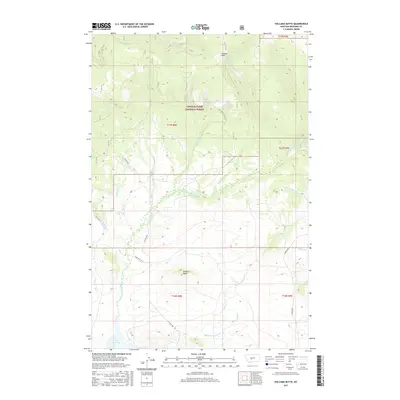
2017 Map of Volcano Butte
USGS Topo · Published 2017About this map
Volcano Butte rises as a prominent landmark in this section of Meagher County, situated within the expansive Lewis & Clark National Forest. The landscape is defined by the headwaters and drainage networks of the N Fork Smith River and the N Fork Eightmile Cr, which carve through the high terrain. In the northern reaches, Higgins Park provides a notable clearing amidst the timbered slopes, while Lake Sutherlin sits in the southwestern portion of the quadrangle. Transportation through this remote mountain geography is facilitated by a network of forest and county roads, including CO Hwy 830 and the Jamison Trl. The map details a complex system of seasonal and perennial streams like Moss Cr, Geis Cr, and Copper Cr, illustrating the vital water resources that sustain this forest environment.
Find a feature on this map
22 named features on this map. Tap any name to fly to it.
Don’t see what you’re looking for? This feature index may not catch every label — zoom into the map to look around manually.
Map Details
Editions of this 2017 Volcano Butte Map
This is the sole edition of this map. No revisions or reprints were ever made.
Other maps of this area

1886 · Little Belt Mts.
USGS Topo · 1:250,000

1894 · Little Belt Mts.
USGS Topo · 1:250,000

1897 · Little Belt Mts.
USGS Topo · 1:250,000

1898 · Little Belt Mts.
USGS Topo · 1:250,000

1902 · Little Belt Mts.
USGS Topo · 1:250,000

1948 · White Sulphur Springs
USGS Topo · 1:250,000

1958 · White Sulphur Springs
USGS Topo · 1:250,000

1961 · White Sulphur Springs
USGS Topo · 1:250,000
1961 · Kings Hill
USGS Topo · 1:24,000
1961 · Sand Point
USGS Topo · 1:24,000