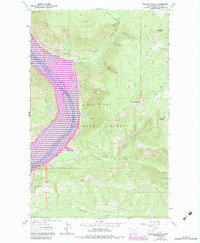
1983 Map of Volcour Gulch
USGS Topo · Published 1984About this map
Lake Koocanusa dominates this portion of the Kootenai National Forest, its reservoir waters backed up behind the Libby Dam. This 1980s revision highlights the altered shoreline of the Kootenai River, with purple overlays indicating changes to the landscape since the original 1960s photogrammetric mapping. The settlement of Warland is shown near the southern edge along the banks of Warland Creek, serving as a vital point of reference for those researching the displacement of communities following the flooding of the valley.
Find a feature on this map
24 named features on this map. Tap any name to fly to it.
Don’t see what you’re looking for? This feature index may not catch every label — zoom into the map to look around manually.
Map Details
Editions of this 1983 Volcour Gulch Map
This is the sole edition of this map. No revisions or reprints were ever made.
Other maps of this area

1920 · Jennings
USGS Topo · 1:125,000

1935 · Thompson Lakes
USGS Topo · 1:96,000

1942 · Thompson Lakes
USGS Topo · 1:125,000

1957 · Kalispell
USGS Topo · 1:250,000

1960 · Kalispell
USGS Topo · 1:250,000

1961 · Kalispell
USGS Topo · 1:250,000

1963 · Mc Guire Mountain
USGS Topo · 1:24,000

1963 · Davis Mountain
USGS Topo · 1:24,000

1963 · Warland Peak
USGS Topo · 1:24,000

1963 · Cripple Horse Mountain
USGS Topo · 1:24,000