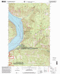
1997 Map of Volcour Gulch
USGS Topo · Published 2000About this map
Lake Koocanusa dominates the western half of this Lincoln County landscape, a reservoir formed by the damming of the Kootenai River. The map captures the rugged mountain terrain of the Kootenai National Forest during the late twentieth century, showing a network of forest roads managed by the Rexford Fisher River Ranger District and Rexford Fortine Ranger District. To the east, high peaks such as Stenerson Mountain, Mineral Mountain, and Huckleberry Mountain define the horizon.
Find a feature on this map
28 named features on this map. Tap any name to fly to it.
Don’t see what you’re looking for? This feature index may not catch every label — zoom into the map to look around manually.
Map Details
Editions of this 1997 Volcour Gulch Map
This is the sole edition of this map. No revisions or reprints were ever made.
Other maps of this area

1920 · Jennings
USGS Topo · 1:125,000

1935 · Thompson Lakes
USGS Topo · 1:96,000

1942 · Thompson Lakes
USGS Topo · 1:125,000

1957 · Kalispell
USGS Topo · 1:250,000

1960 · Kalispell
USGS Topo · 1:250,000

1961 · Kalispell
USGS Topo · 1:250,000

1963 · Mc Guire Mountain
USGS Topo · 1:24,000

1963 · Davis Mountain
USGS Topo · 1:24,000

1963 · Warland Peak
USGS Topo · 1:24,000

1963 · Cripple Horse Mountain
USGS Topo · 1:24,000