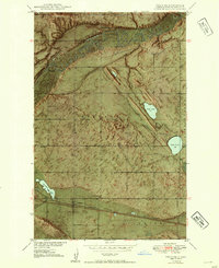
1949 Map of Voltaire
USGS Topo · Published 1954About this map
The Minneapolis St Paul and Sault Ste Marie railroad defines the southern landscape of this McHenry County region, anchoring the small settlement of Voltaire. This 1949 survey illustrates a rural community tied to the land and the rails, with landmarks like the Hjerdal Ch and a nearby Gravel Pit serving as local focal points. The northern half of the map is dominated by the winding path of the Souris River, which carves through the township of Hendrickson.
Find a feature on this map
20 named features on this map. Tap any name to fly to it.
Don’t see what you’re looking for? This feature index may not catch every label — zoom into the map to look around manually.
Map Details
Editions of this 1949 Voltaire Map
2 editions found
Other maps of this area

1929 · Kongsberg
USGS Topo · 1:62,500

1929 · Balfour
USGS Topo · 1:62,500

1948 · Voltaire
USGS Topo · 1:24,000

1948 · Velva
USGS Topo · 1:62,500

1949 · Norwich
USGS Topo · 1:24,000

1949 · Simcoe
USGS Topo · 1:24,000

1949 · Velva
USGS Topo · 1:24,000

1949 · Voltaire
USGS Topo · 1:24,000

1949 · Karlsruhe NW
USGS Topo · 1:24,000

1951 · Velva
USGS Topo · 1:62,500