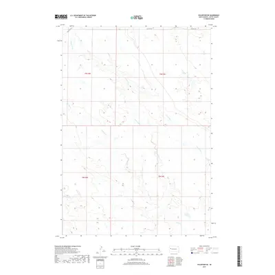
2017 Map of Volunteer NE
USGS Topo · Published 2017About this map
Station Elm Cr and several other branching tributaries define this section of the South Dakota prairie north of Belle Fourche. The landscape is marked by a complex drainage system where Mud Elm Cr, Crooked Elm Cr, and Eightmile Cr carve through the open terrain of Butte County. This 2017 survey reveals a sparsely populated ranching environment where section lines dictate the boundary of land tracts like t9n r9e and t8n r8e. Historical transportation routes are evident in the northwestern corner, where the path of Old US Hwy 212 cuts across the section lines near the crossing of Station Elm Cr, while Fair Point Rd runs along the northern edge of the quadrangle. The map captures the subtle water features and road networks essential to the rural economy of this High Plains region.
Find a feature on this map
12 named features on this map. Tap any name to fly to it.
Don’t see what you’re looking for? This feature index may not catch every label — zoom into the map to look around manually.
Map Details
Editions of this 2017 Volunteer NE Map
This is the sole edition of this map. No revisions or reprints were ever made.
Other maps of this area

1913 · Newell
USGS Topo · 1:125,000

1951 · Volunteer
USGS Topo · 1:24,000

1951 · Volunteer SE
USGS Topo · 1:24,000

1953 · Rapid City
USGS Topo · 1:250,000

1957 · Rapid City
USGS Topo · 1:250,000

1959 · Fairpoint SW
USGS Topo · 1:24,000
1959 · Volunteer NW
USGS Topo · 1:24,000
1959 · Volunteer NE
USGS Topo · 1:24,000

1959 · Fairpoint NW
USGS Topo · 1:24,000
1973 · Owl Butte
USGS Topo · 1:24,000