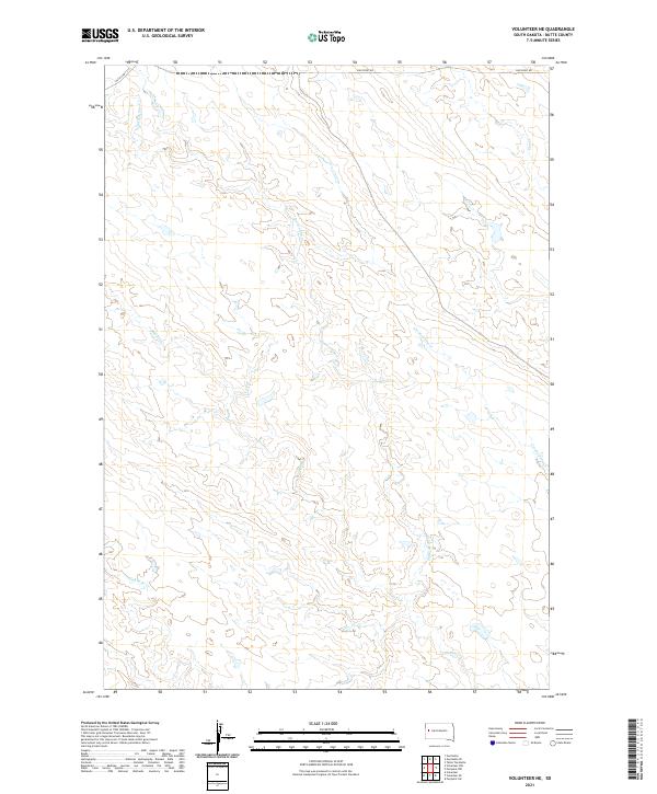
2021 Map of Volunteer NE
USGS Topo · Published 2021About this map
Station Elm Cr and its numerous tributaries define the drainage patterns across this portion of Butte County. The landscape is characterized by the complex branching of waterways such as Crooked Elm Cr, Mud Elm Cr, and W Elm Cr, which transition through open rangeland. Transportation is centered on the historic corridor of Old Us Hwy 212 in the northwest corner and Fair Point Rd along the northern boundary, reflecting the enduring path of travel in this rural region. The survey details the township and range divisions, including t9n r9e and t8n r8e, providing a clear view of the land partitions used for ranching and resource management in the early 21st century. This modern USGS topographic study captures the precise hydrology of the Elm Cr system before it joins larger regional watersheds.
Find a feature on this map
12 named features on this map. Tap any name to fly to it.
Don’t see what you’re looking for? This feature index may not catch every label — zoom into the map to look around manually.
Map Details
Editions of this 2021 Volunteer NE Map
This is the sole edition of this map. No revisions or reprints were ever made.
Other maps of this area

1913 · Newell
USGS Topo · 1:125,000

1951 · Volunteer
USGS Topo · 1:24,000

1951 · Volunteer SE
USGS Topo · 1:24,000

1953 · Rapid City
USGS Topo · 1:250,000

1957 · Rapid City
USGS Topo · 1:250,000

1959 · Fairpoint SW
USGS Topo · 1:24,000
1959 · Volunteer NW
USGS Topo · 1:24,000
1959 · Volunteer NE
USGS Topo · 1:24,000

1959 · Fairpoint NW
USGS Topo · 1:24,000
1973 · Owl Butte
USGS Topo · 1:24,000