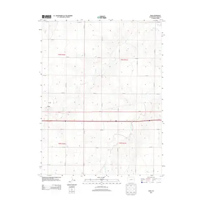
2013 Map of Vona
USGS Topo · Published 2013About this map
Vona serves as the primary hub of this Kit Carson County landscape, situated where the grid of agricultural roads meets the transport corridor of Us-24 E. The town's layout and the nearby Vona Cem suggest a settled farming community shaped by the High Plains environment. The terrain is defined by the subtle drainages of Spring Cr and its various forks, including the East Branch Spring Creek. These intermittent waterways cut through the sections, creating the only significant relief in an otherwise strictly organized sectional grid. The map illustrates a highly structured rural economy, where the Public Land Survey System has dictated a precise network of county roads such as Co Road Aa and Co Road 25 that partition the plains into productive blocks.
Find a feature on this map
24 named features on this map. Tap any name to fly to it.
Don’t see what you’re looking for? This feature index may not catch every label — zoom into the map to look around manually.
Map Details
Editions of this 2013 Vona Map
This is the sole edition of this map. No revisions or reprints were ever made.
Other maps of this area

1954 · Limon
USGS Topo · 1:250,000

1957 · Limon
USGS Topo · 1:250,000

1958 · Limon
USGS Topo · 1:250,000

1969 · Alpine Ranch NE
USGS Topo · 1:24,000

1969 · Tuttle
USGS Topo · 1:24,000

1969 · Stratton
USGS Topo · 1:24,000

1979 · Vona
USGS Topo · 1:24,000

1979 · Seibert NE
USGS Topo · 1:24,000
1979 · Alpine Ranch NW
USGS Topo · 1:24,000

1979 · Stratton 3 NE
USGS Topo · 1:24,000