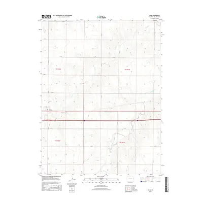
2016 Map of Vona
USGS Topo · Published 2016About this map
Vona stands as the primary settlement on this eastern Colorado high plains landscape, situated along the major transportation corridor that bisects the region. The town's enduring local history is marked by the Vona Cem, located just to the north of the main residential cluster. The surrounding terrain is defined by a distinct grid of county roads, such as Co RD 23 and Co RD Aa, which delineate the agricultural sections typical of Kit Carson County. These roads follow the township and range boundaries of t8s r48w and t8s r47w, illustrating the systematic land division of the West. Drainage for the area is provided by the winding paths of Spring Cr and its tributaries, including East Branch Spring Creek, which cut subtle topographic variations into the flat plains. This map captures the intersection of rural infrastructure and the natural intermittent waterways that have shaped local settlement patterns for generations.
Find a feature on this map
22 named features on this map. Tap any name to fly to it.
Don’t see what you’re looking for? This feature index may not catch every label — zoom into the map to look around manually.
Map Details
Editions of this 2016 Vona Map
This is the sole edition of this map. No revisions or reprints were ever made.
Other maps of this area

1954 · Limon
USGS Topo · 1:250,000

1957 · Limon
USGS Topo · 1:250,000

1958 · Limon
USGS Topo · 1:250,000

1969 · Alpine Ranch NE
USGS Topo · 1:24,000

1969 · Tuttle
USGS Topo · 1:24,000

1969 · Stratton
USGS Topo · 1:24,000

1979 · Vona
USGS Topo · 1:24,000

1979 · Seibert NE
USGS Topo · 1:24,000
1979 · Alpine Ranch NW
USGS Topo · 1:24,000

1979 · Stratton 3 NE
USGS Topo · 1:24,000