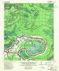
1941 Map of Voorhies
USGS Topo · Published 1954About this map
Bordelonville and Moreauville anchor this 1941 landscape, which is defined by the intricate relationship between the Red River and the winding Bayou des Glaises. The map reveals a complex alluvial environment where oxbow lakes like Lake Roseau and Sutton Lake populate the central Pomme De Terre Swamp. Significant human infrastructure is seen along the Texas and Pacific RR and at the settlement of Hamburg, which serves as a junction for local transport.
Find a feature on this map
95 named features on this map. Tap any name to fly to it.
Don’t see what you’re looking for? This feature index may not catch every label — zoom into the map to look around manually.
Map Details
Editions of this 1941 Voorhies Map
2 editions found
Other maps of this area

1935 · Tooleys
USGS Topo · 1:62,500

1939 · Artonish
USGS Topo · 1:62,500

1939 · Deer Park
USGS Topo · 1:62,500

1940 · Marksville
USGS Topo · 1:62,500

1941 · Voorhies
USGS Topo · 1:62,500

1941 · Buckeye
USGS Topo · 1:62,500

1941 · Batchelor
USGS Topo · 1:62,500

1941 · Tooleys
USGS Topo · 1:62,500

1948 · Bunkie
USGS Topo · 1:62,500

1952 · Lake Charles
USGS Topo · 1:250,000