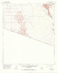
1965 Map of Vopoki Ridge
USGS Topo · Published 1966About this map
Luke Air Force Range dominates this desert landscape in southern Arizona, where military operations and natural barriers intersect at the international boundary. Surveyed between 1940 and 1965, the sheet documents a rugged environment marked by an Observation Tower and several Target locations used for training. The terrain transitions from the jagged heights of the Gila Mts and Vopoki Ridge in the north to the expansive Davis Plain and shifting Sand Dunes further south. Following the contours of the desert floor, the historic Camino Del Diablo (Jeep Trail) traces an approximate path through the arid wilderness. Along the southern edge, the border between the United States and Mexico is clearly delineated, alongside the state line of Arizona and Sonora.
Find a feature on this map
15 named features on this map. Tap any name to fly to it.
Don’t see what you’re looking for? This feature index may not catch every label — zoom into the map to look around manually.
Map Details
Editions of this 1965 Vopoki Ridge Map
2 editions found
Other maps of this area

1903 · Yuma
USGS Topo · 1:125,000

1905 · Yuma
USGS Topo · 1:125,000

1926 · Fortuna
USGS Topo · 1:62,500

1926 · Wellton
USGS Topo · 1:62,500

1929 · Fortuna
USGS Topo · 1:62,500

1929 · Wellton
USGS Topo · 1:62,500

1940 · Yuma
USGS Topo · 1:62,500

1942 · Yuma
USGS Topo · 1:250,000

1945 · Yuma
USGS Topo · 1:62,500

1954 · El Centro
USGS Topo · 1:250,000