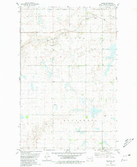
1980 Map of Wabek
USGS Topo · Published 1981About this map
Wabek and the northern reaches of the Fort Berthold Indian Reservation Boundary anchor this 1980s topographic study of Mountrail County. The landscape is defined by the winding course of Shell Creek in the north and Deepwater Creek further south, interspersed with the numerous prairie potholes characteristic of the region. The small community of Wabek serves as a local focal point, featuring a Townhall, the Lutheran Ch, and the nearby Lutheran Cem. Transportation and commerce are marked by the Soo Line railroad, which cuts through the northeast corner of the quadrangle near Prairie Junction. The presence of several Gravel Pits suggests the local extractive industries supporting regional infrastructure during this period. The map provides a clear look at the section-line road network and the dispersed agricultural homesteads that shaped the rural character of the North Dakota plains during the late twentieth century.
Find a feature on this map
12 named features on this map. Tap any name to fly to it.
Don’t see what you’re looking for? This feature index may not catch every label — zoom into the map to look around manually.
Map Details
Editions of this 1980 Wabek Map
This is the sole edition of this map. No revisions or reprints were ever made.
Other maps of this area

1953 · Williston
USGS Topo · 1:250,000

1953 · Watford City
USGS Topo · 1:250,000

1954 · Minot
USGS Topo · 1:250,000

1954 · McClusky
USGS Topo · 1:250,000

1956 · Makoti SW
USGS Topo · 1:24,000

1956 · Roseglen
USGS Topo · 1:24,000

1957 · Williston
USGS Topo · 1:250,000

1957 · Watford City
USGS Topo · 1:250,000

1958 · McClusky
USGS Topo · 1:250,000

1958 · Minot
USGS Topo · 1:250,000