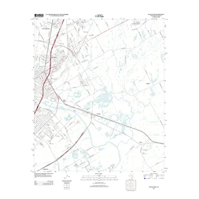
2012 Map of Waco East
USGS Topo · Published 2012About this map
The Brazos River carves a path through this landscape, separating the core of East Waco from its suburban extensions and neighboring communities. This 2012 record captures the complex transportation and residential expansion of McLennan County, where Bellmead and Lacy-Lakeview have grown into dense networks of streets like W Craven Ave and E Industrial Blvd. The map provides significant genealogical value, identifying numerous local burial grounds including Oakwood Cem, Rosemound Cem, and the Miller Memorial Cem. Educational and aviation landmarks are prominent, from the sprawling campus of Baylor Univ to specialized facilities like the Wings For Christ International Flight Academy Airport and Flying Heart Ranch Airport. Smaller settlements such as Wardlaw and Neale are also documented, alongside natural features like Tehuacana Cr and Stratton Lake.
Find a feature on this map
201 named features on this map. Tap any name to fly to it.
Don’t see what you’re looking for? This feature index may not catch every label — zoom into the map to look around manually.
Map Details
Editions of this 2012 Waco East Map
This is the sole edition of this map. No revisions or reprints were ever made.
Other maps of this area

1892 · Temple
USGS Topo · 1:125,000

1892 · Waco
USGS Topo · 1:125,000

1920 · Waco
USGS Topo · 1:125,000

1920 · Mart
USGS Topo · 1:62,500

1924 · Waco 4-c
USGS Topo · 1:48,000

1931 · Elm Mott
USGS Topo · 1:62,500

1954 · Waco
USGS Topo · 1:250,000

1955 · Waco
USGS Topo · 1:250,000

1956 · Axtell
USGS Topo · 1:24,000
1957 · Gholson
USGS Topo · 1:24,000