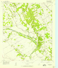
1957 Map of Gholson
USGS Topo · Published 1958About this map
Aquilla Creek and the Brazos River dominate this central Texas landscape, creating a network of drainage patterns that includes Dry Creek, Rock Creek, and Salem Branch. The community of Gholson serves as a central hub, connected by the Gholson Road and supported by local institutions like Gholson School and several nearby churches. The presence of multiple burial grounds, such as Pleasant Grove Cemetery and Jenkins Cemetery, provides significant documentation for genealogical research in this part of McLennan County.
Find a feature on this map
31 named features on this map. Tap any name to fly to it.
Don’t see what you’re looking for? This feature index may not catch every label — zoom into the map to look around manually.
Map Details
Editions of this 1957 Gholson Map
Other maps of this area

1892 · Waco
USGS Topo · 1:125,000

1920 · Waco
USGS Topo · 1:125,000

1924 · Waco 4-c
USGS Topo · 1:48,000

1924 · Waco 3-d
USGS Topo · 1:48,000

1931 · Whitney
USGS Topo · 1:62,500

1931 · Valley Mills
USGS Topo · 1:62,500

1931 · Elm Mott
USGS Topo · 1:62,500

1954 · Waco
USGS Topo · 1:250,000

1955 · Waco
USGS Topo · 1:250,000

1956 · West
USGS Topo · 1:24,000