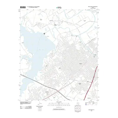
2010 Map of Waco West
USGS Topo · Published 2010About this map
Waco and its western suburbs are defined by the massive expanse of Waco Lake and the winding course of the Brazos River. This 2010 topographic record illustrates the dense urban grid of the city center, featuring the landmark Waco Suspension Bridge and Washington Avenue Bridge, which connect the downtown area to the northern riverbanks. The landscape transitions from the urban core toward the residential developments of Woodway and Beverly Hills, while the western shore of the lake remains dominated by recreational and infrastructure assets like the Waco Dam and Waco Regional Airport. Near the river's bend, prominent natural features such as Lovers Leap and Emmons Cliff overlook the water, marking the transition from the river valley to the surrounding plateaus. Local history is anchored by sites like Whitehall Cemetery and the Heart O' Texas Fairground, providing points of reference for genealogists and researchers studying the expansion of Central Texas at the turn of the 21st century.
Find a feature on this map
62 named features on this map. Tap any name to fly to it.
Don’t see what you’re looking for? This feature index may not catch every label — zoom into the map to look around manually.
Map Details
Editions of this 2010 Waco West Map
This is the sole edition of this map. No revisions or reprints were ever made.
Other maps of this area

1892 · Temple
USGS Topo · 1:125,000

1892 · Waco
USGS Topo · 1:125,000

1920 · Waco
USGS Topo · 1:125,000

1924 · Waco 4-c
USGS Topo · 1:48,000

1924 · Waco 3-d
USGS Topo · 1:48,000

1931 · Valley Mills
USGS Topo · 1:62,500

1931 · Elm Mott
USGS Topo · 1:62,500

1931 · Mc Gregor
USGS Topo · 1:62,500

1954 · Waco
USGS Topo · 1:250,000

1955 · Waco
USGS Topo · 1:250,000