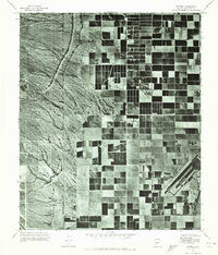
1971 Map of Waddell
USGS Topo · Published 1972About this map
Luke Air Force Base occupies the southeastern corner of this orthophotoquad, showing the early 1970s footprint of the facility's runways and support structures. The landscape is a stark study in the transition between the arid terrain to the west and the organized geometry of agriculture to the east. Agricultural development, marked by the rigid grid of fields and groves, is serviced by the Beardsley Canal, which cuts through the transition zone where the alluvial fans meet the valley floor. Small residential clusters like Waddell and Citrus Park appear as modest outposts within this expansive farming region. The aerial imagery captured in 1971 reveals the systematic layout of the desert irrigation system before the rapid suburbanization of Maricopa County reached this far west.
Find a feature on this map
4 named features on this map. Tap any name to fly to it.
Don’t see what you’re looking for? This feature index may not catch every label — zoom into the map to look around manually.
Map Details
Editions of this 1971 Waddell Map
This is the sole edition of this map. No revisions or reprints were ever made.
Other maps of this area

1946 · Avondale
USGS Topo · 1:62,500

1948 · Cashion
USGS Topo · 1:62,500

1954 · Phoenix
USGS Topo · 1:250,000

1957 · Phoenix
USGS Topo · 1:250,000

1957 · White Tank Mts. SE
USGS Topo · 1:24,000

1957 · Valencia
USGS Topo · 1:24,000

1957 · Perryville
USGS Topo · 1:24,000

1957 · White Tank Mts. NE
USGS Topo · 1:24,000

1957 · Calderwood Butte
USGS Topo · 1:24,000

1957 · McMicken Dam
USGS Topo · 1:24,000