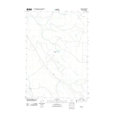
2011 Map of Wade
USGS Topo · Published 2011About this map
Wade and the surrounding Carbon County landscape appear here in the early 21st century, defined by a network of drainage systems and isolated outposts. The settlement patterns of this high plains region are traced through markers like Parker Cabin in the north and Baker Cabin near Castle Coulee in the southwest. Water management is a primary feature of the local topography, highlighted by the Depression Reservoir and the accompanying Depression Detention Dam which capture seasonal runoff. The map documents the convergence of several waterways, including Jack Creek, Bridger Creek, and its various branches. Transportation in this area is sparse, primarily centered on Pryor Mountain Rd, which provides access through the drainage-carved terrain. This survey reflects a landscape where human presence remains limited to strategic cabins and small-scale infrastructure within a complex hydraulic system.
Find a feature on this map
12 named features on this map. Tap any name to fly to it.
Don’t see what you’re looking for? This feature index may not catch every label — zoom into the map to look around manually.
Map Details
Editions of this 2011 Wade Map
This is the sole edition of this map. No revisions or reprints were ever made.
Other maps of this area

1954 · Billings
USGS Topo · 1:250,000

1956 · Bridger
USGS Topo · 1:24,000

1957 · Billings
USGS Topo · 1:250,000

1958 · Billings
USGS Topo · 1:250,000

1967 · Section House Draw
USGS Topo · 1:24,000

1967 · Bluewater
USGS Topo · 1:24,000

1969 · Warren
USGS Topo · 1:24,000

1969 · Bowler
USGS Topo · 1:24,000
1969 · Hatcher Pass
USGS Topo · 1:24,000
1969 · Hunters Creek
USGS Topo · 1:24,000