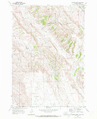
1969 Map of Hunters Creek
USGS Topo · Published 1973About this map
Elk Basin Oil Field operations and scattered mountain outposts define this 1969 topographic survey of the borderlands between Montana and Wyoming. The landscape is marked by several remote dwellings, including Maki Cabin and Lee Guard Cabin, which suggest the area’s historic use for ranching or forestry management. A prominent Pipeline cuts through the southern terrain, reflecting the industrial footprint of the regional energy sector during the late 20th century.
Find a feature on this map
26 named features on this map. Tap any name to fly to it.
Don’t see what you’re looking for? This feature index may not catch every label — zoom into the map to look around manually.
Map Details
Editions of this 1969 Hunters Creek Map
2 editions found
Other maps of this area

1954 · Billings
USGS Topo · 1:250,000

1955 · Cody
USGS Topo · 1:250,000

1957 · Billings
USGS Topo · 1:250,000

1958 · Billings
USGS Topo · 1:250,000

1958 · Cody
USGS Topo · 1:250,000

1962 · Cody
USGS Topo · 1:250,000

1966 · Elk Basin
USGS Topo · 1:24,000

1966 · Elk Basin NW
USGS Topo · 1:24,000

1966 · Deaver Reservoir
USGS Topo · 1:24,000

1969 · Warren
USGS Topo · 1:24,000