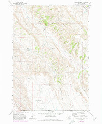
1969 Map of Hunters Creek
USGS Topo · Published 1980About this map
The Elk Basin Oil Field dominates the southwestern corner of this 1969 topographic survey, marking the intersection of the Montana-Wyoming border. This high-desert landscape is defined by its drainage systems and remote outposts, such as Maki Cabin, Lee Guard Cabin, and Mud Spring Cabin. The terrain is characterized by deep erosional features like Weatherman Draw and Castle Coulee, while human activity is evidenced by a prominent north-south Pipeline and the Burlington Northern railroad corridor in the northeast. Water management in this arid environment is visible through small-scale infrastructure like Hunters Reservoir and Jones Reservoir, which capture runoff from Hunters Creek and Little Hunters Creek. The map records a moment of industrial and livestock activity before modern consolidation, preserving the locations of specific cabins and early petroleum development in Carbon County.
Find a feature on this map
25 named features on this map. Tap any name to fly to it.
Don’t see what you’re looking for? This feature index may not catch every label — zoom into the map to look around manually.
Map Details
Editions of this 1969 Hunters Creek Map
2 editions found
Other maps of this area

1954 · Billings
USGS Topo · 1:250,000

1955 · Cody
USGS Topo · 1:250,000

1957 · Billings
USGS Topo · 1:250,000

1958 · Billings
USGS Topo · 1:250,000

1958 · Cody
USGS Topo · 1:250,000

1962 · Cody
USGS Topo · 1:250,000

1966 · Elk Basin
USGS Topo · 1:24,000

1966 · Elk Basin NW
USGS Topo · 1:24,000

1966 · Deaver Reservoir
USGS Topo · 1:24,000

1969 · Warren
USGS Topo · 1:24,000