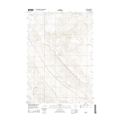
2014 Map of Wade
USGS Topo · Published 2014About this map
Wade serves as a central point along the path of Us-310 in this Carbon County region, where the landscape is defined by the elevation of Pryor Mountain and the intricate drainage of the Bridger Creek system. The map details an environment of managed water and complex topography, featuring the Depression Reservoir and the Mutual Ditch, which indicate the importance of water rights and irrigation in this high-plains setting. Watercourses like S Fork Bridger Cr and Jack Cr carve through the terrain, punctuated by landforms such as Castle Coulee. This 2014 survey documents the modern layout of the road network, including Pryor Mountain Rd and Cottonwood Rd, showing how transportation routes are dictated by the natural draws and ridges of the Montana backcountry.
Find a feature on this map
18 named features on this map. Tap any name to fly to it.
Don’t see what you’re looking for? This feature index may not catch every label — zoom into the map to look around manually.
Map Details
Editions of this 2014 Wade Map
This is the sole edition of this map. No revisions or reprints were ever made.
Other maps of this area

1954 · Billings
USGS Topo · 1:250,000

1956 · Bridger
USGS Topo · 1:24,000

1957 · Billings
USGS Topo · 1:250,000

1958 · Billings
USGS Topo · 1:250,000

1967 · Section House Draw
USGS Topo · 1:24,000

1967 · Bluewater
USGS Topo · 1:24,000

1969 · Warren
USGS Topo · 1:24,000

1969 · Bowler
USGS Topo · 1:24,000
1969 · Hatcher Pass
USGS Topo · 1:24,000
1969 · Hunters Creek
USGS Topo · 1:24,000