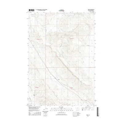
2017 Map of Wade
USGS Topo · Published 2017About this map
Wade serves as a primary geographic marker in this section of Carbon County, where the high-plains landscape is defined by an intricate network of seasonal and perennial drainage systems. The irrigation history of the region is evident through the Mutual Ditch, which cuts through the northern sections, while the natural topography is shaped by the carved paths of Bridger Cr and its northern and southern forks. Further south, Castle Coulee and Cottonwood Cr provide distinct terrain markers for those tracing historical land use or watershed patterns.
Find a feature on this map
16 named features on this map. Tap any name to fly to it.
Don’t see what you’re looking for? This feature index may not catch every label — zoom into the map to look around manually.
Map Details
Editions of this 2017 Wade Map
This is the sole edition of this map. No revisions or reprints were ever made.
Other maps of this area

1954 · Billings
USGS Topo · 1:250,000

1956 · Bridger
USGS Topo · 1:24,000

1957 · Billings
USGS Topo · 1:250,000

1958 · Billings
USGS Topo · 1:250,000

1967 · Section House Draw
USGS Topo · 1:24,000

1967 · Bluewater
USGS Topo · 1:24,000

1969 · Warren
USGS Topo · 1:24,000

1969 · Bowler
USGS Topo · 1:24,000
1969 · Hatcher Pass
USGS Topo · 1:24,000
1969 · Hunters Creek
USGS Topo · 1:24,000