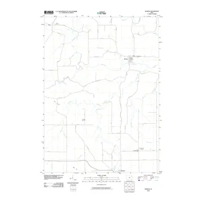
2010 Map of Wadena
USGS Topo · Published 2010About this map
Wadena and Arlington anchor this topographic view of the rolling Fayette County landscape, where the Volga River carves a winding path through the northern half of the quadrangle. For genealogists and local historians, the map is remarkably dense with burial sites, including the Lima Cemetery, Corn Hill Cemetery, and Saint Josephs Cemetery. These sites are often found near early settlement points like Lima and Taylorsville, reflecting the deep agricultural roots of the region. The drainage patterns are defined by numerous creeks such as Brush Creek, Mink Creek, and Deep Creek, which dictate the placement of the rural road network. The presence of the Wadena Post Office and the clustering of roads around the main settlements highlights the long-standing community centers of the area. Distinctive landmarks like Corn Hill and Bear Hill provide clear reference points for those tracing family land tracts across this portion of northeast Iowa.
Find a feature on this map
48 named features on this map. Tap any name to fly to it.
Don’t see what you’re looking for? This feature index may not catch every label — zoom into the map to look around manually.
Map Details
Editions of this 2010 Wadena Map
This is the sole edition of this map. No revisions or reprints were ever made.
Other maps of this area

1901 · Oelwein
USGS Topo · 1:125,000

1959 · Dubuque
USGS Topo · 1:250,000

1961 · Dubuque
USGS Topo · 1:250,000

1962 · Dubuque
USGS Topo · 1:250,000

1965 · Elgin
USGS Topo · 1:24,000

1965 · Wadena
USGS Topo · 1:24,000
1965 · Gunder
USGS Topo · 1:24,000

1965 · Strawberry Point
USGS Topo · 1:24,000

1965 · Arlington
USGS Topo · 1:24,000
1965 · Volga
USGS Topo · 1:24,000