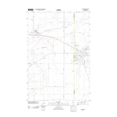
2013 Map of Wadena
USGS Topo · Published 2013About this map
Wadena serves as the primary hub in this portion of central Minnesota, situated at the junction of Us-10 and MN-29. The town's layout is defined by a dense grid of streets including Aldrich Ave SW and Franklin Ave SW, while the broader landscape is shaped by the meandering course of the Leaf River. To the west, the village of Bluffton and the residential development of West Wind Estates sit near the confluence of Bluff Cr and the river, marking a distinct pocket of settlement. Local heritage is preserved in several burial grounds scattered across the township, such as Gustafva Cem and Compton Cem, which provide specific points of interest for genealogical research. The presence of the Wadena Municipal Airport and a network of county roads like Co HWY-75 illustrate the modern transportation infrastructure that connects these rural agricultural lands.
Find a feature on this map
76 named features on this map. Tap any name to fly to it.
Don’t see what you’re looking for? This feature index may not catch every label — zoom into the map to look around manually.
Map Details
Editions of this 2013 Wadena Map
This is the sole edition of this map. No revisions or reprints were ever made.
Other maps of this area

1953 · Brainerd
USGS Topo · 1:250,000

1957 · Brainerd
USGS Topo · 1:250,000

1958 · Brainerd
USGS Topo · 1:250,000

1965 · Brainerd
USGS Topo · 1:250,000

1969 · Sebeka SW
USGS Topo · 1:24,000

1969 · Henning SE
USGS Topo · 1:24,000

1969 · Bertha
USGS Topo · 1:24,000

1969 · Wrightstown
USGS Topo · 1:24,000

1969 · Wadena
USGS Topo · 1:24,000
1969 · Deer Creek
USGS Topo · 1:24,000