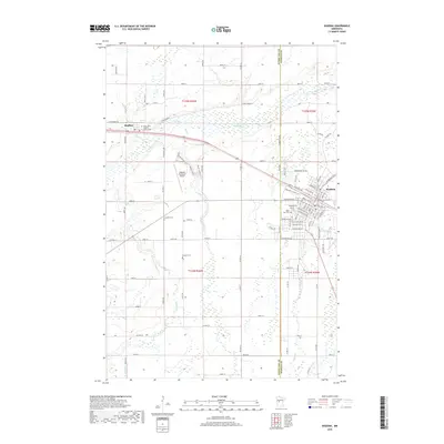
2019 Map of Wadena
USGS Topo · Published 2019About this map
Wadena and Bluffton serve as the primary hubs in this region of central Minnesota, where the BNSF Railway and Highway 10 facilitate movement through a landscape defined by the Leaf River and its tributaries. The proximity of the Wadena Municipal Airport and the dense street grid of Wadena contrast with the surrounding rural townships, where numerous cemeteries such as Gustafva Cem and Compton Cem suggest long-standing community roots. Further west, the terrain is marked by Blacks Grove and the winding course of Bluff Cr and S Bluff Cr. This map documents a transitional geography between agricultural plots and wooded river valleys, anchored by local landmarks including Saint John's Catholic Church Cem near the river bend.
Find a feature on this map
111 named features on this map. Tap any name to fly to it.
Don’t see what you’re looking for? This feature index may not catch every label — zoom into the map to look around manually.
Map Details
Editions of this 2019 Wadena Map
This is the sole edition of this map. No revisions or reprints were ever made.
Other maps of this area

1953 · Brainerd
USGS Topo · 1:250,000

1957 · Brainerd
USGS Topo · 1:250,000

1958 · Brainerd
USGS Topo · 1:250,000

1965 · Brainerd
USGS Topo · 1:250,000

1969 · Sebeka SW
USGS Topo · 1:24,000

1969 · Henning SE
USGS Topo · 1:24,000

1969 · Bertha
USGS Topo · 1:24,000

1969 · Wrightstown
USGS Topo · 1:24,000

1969 · Wadena
USGS Topo · 1:24,000
1969 · Deer Creek
USGS Topo · 1:24,000