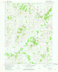
1981 Map of Wadesville
USGS Topo · Published 1981About this map
The rolling landscape of Posey County in the early 1980s reveals a patchwork of traditional farming and mid-century energy development. The town of Wadesville serves as a primary hub, while the Louisville and Nashville railroad corridor connects smaller settlements like Blairsville and Hepburn. This era is defined by the significant footprint of the petroleum industry, evidenced by the expansive Oliver Underground Gas Storage Area and numerous Oil Fields scattered throughout townships such as Lynn and Robinson.
Find a feature on this map
35 named features on this map. Tap any name to fly to it.
Don’t see what you’re looking for? This feature index may not catch every label — zoom into the map to look around manually.
Map Details
Editions of this 1981 Wadesville Map
This is the sole edition of this map. No revisions or reprints were ever made.
Other maps of this area

1901 · Haubstadt
USGS Topo · 1:62,500

1903 · Haubstadt
USGS Topo · 1:62,500

1903 · New Harmony
USGS Topo · 1:62,500

1903 · Patoka
USGS Topo · 1:125,000

1914 · Henderson
USGS Topo · 1:48,000

1916 · Henderson
USGS Topo · 1:62,500

1917 · Uniontown
USGS Topo · 1:62,500

1938 · New Harmony
USGS Topo · 1:62,500
1952 · Mount Vernon
USGS Topo · 1:24,000

1954 · Evansville
USGS Topo · 1:250,000