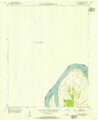
1952 Map of Mount Vernon
USGS Topo · Published 1953About this map
The Ohio River dominates this mid-century survey, acting as the primary geographical divider between Indiana and Kentucky. Focused on the complex riverine environment south of the state line, the map detail centers on Slim Island and the substantial Mt Vernon Towhead, reflecting the dynamic nature of the waterway at a Normal Pool Elevation of 329 feet. The topography reveals the low-lying, swampy character of the bend, evidenced by features like Grassy Pond situated within the alluvial plains. This specific map represents a localized study of the tri-county junction where Henderson, Union, and Posey counties converge along the shifting riverbanks, providing a precise record of the shoreline and internal drainage patterns as they existed just after the 1950 aerial survey.
Find a feature on this map
10 named features on this map. Tap any name to fly to it.
Don’t see what you’re looking for? This feature index may not catch every label — zoom into the map to look around manually.
Map Details
Editions of this 1952 Mount Vernon Map
2 editions found
Other maps of this area

1903 · New Harmony
USGS Topo · 1:62,500

1903 · Patoka
USGS Topo · 1:125,000

1905 · New Haven
USGS Topo · 1:62,500

1906 · New Haven
USGS Topo · 1:62,500

1917 · Uniontown
USGS Topo · 1:62,500

1938 · New Harmony
USGS Topo · 1:62,500

1940 · Carmi
USGS Topo · 1:62,500

1943 · Carmi
USGS Topo · 1:62,500

1949 · Paducah
USGS Topo · 1:250,000

1949 · New Haven
USGS Topo · 1:62,500